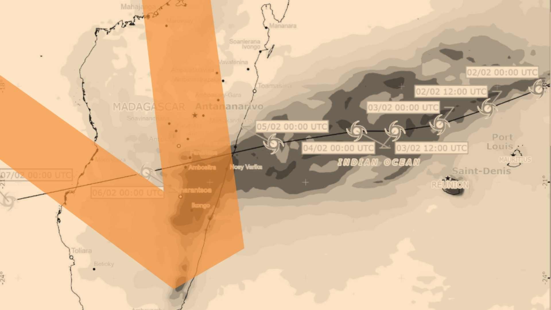
ADAM is a semi-automated system that collects, analyzes, maps and distributes geospatial information to prepare, warn and respond to sudden onset emergencies. Currently operational for floods, earthquakes and tropical storms, ADAM issues timely public alerts and response products aggregating evidence-based, satellite-derived, near-real time risk and impact information.
“Verified” – delivering science-based information in times of crises
A joint initiative of Purpose and the United Nations, Verified is a crisis communications model designed to adeptly respond to intersecting crises in an era of prolific mis- and disinformation. Heavily based on behavioral science insights, it cuts through the noise around global crises and deliver critical fact-based advice and information.
The Reference Death Archive is a global repository of deaths with matched pathology-based biomarkers, WHO verbal autopsy data, and independently assigned reference causes of death, designed to provide high-quality evidence to improve, validate, and standardize verbal autopsy methods and algorithms for cause of death assertion.
Data4Now Initiative: Delivering the Information Needed for Designing Effective Development Programmes
The Data For Now initiative (Data4Now), aims to develop countries’ capacities to deliver the information needed by local and national policy and decision makers to design effective development strategies and policy programmes to achieve the 2030 Agenda and make a positive difference in people’s lives. To this end, it supports members of the National Statistical Systems in participating countries to leverage innovative sources, technologies, methods and partnerships for the streamlined production and dissemination of better, more timely and disaggregated data for sustainable development. In this context, it also supports effective collaboration between members of the National Statistical System, local, national, and global partners from intergovernmental organizations, academia, civil society, and the private sector. Visit our website for more information: https://unstats.un.org/UNSDWebsite/capacity-development/data-for-now/
R3imagine Immersive: A Museum Bridging Art, Tech & Impact
A cutting-edge immersive museum at the intersection of art, technology, and impact on a mission to imagine and build a positive future. We inspire hope for the future through enchanting immersive experiences, technological innovation, and socially engaged discussion. Aligned with the United Nations 2030 agenda, we foster imaginative solutions that drive real-world change. We center the imaginations of historically marginalized communities, fostering a vibrant space for intercultural exchange and world-class arts entertainment.
Digital Government Academy: Skills and Knowledge for Civil Servants
The Digital Government Academy equips civil servants with the skills and knowledge needed to prototype, implement, operate and expand the use of user-centric digital government systems.
The UNDRR and WMO have developed a Global Observatory for EWS Financial Tracking to support the UN Secretary-General’s Early Warnings for All (EW4All) initiative. This tool systematically tracks investments in Early Warning Systems (EWS) using a standardized taxonomy, transforming how stakeholders manage, visualize, and analyze data.
Leadership, Orientation and Guidance for Operational Support (LOGOS)
Leadership, Orientation and Guidance for Operational Support (LOGOS) is a flagship programme that equips the next generation of field leaders, particularly prospective Chiefs/Directors of Mission Support (C/DMS), to lead effectively in complex, field-based environments.
UNDP Mexico’s Data Platform for Analysis for Development
Public space with digital tools for data consultation and analysis, online learning and training, and evidence-based decision-making on development issues.
“Transformative Spaces” is a collective initiative across UN partners whose goal is to convene “safe and inclusive spaces for connection, dialogue, co-creation and transformation” and amplify these across different workspaces and networks of engagement and dialogue.
The Global Network of Digital Agriculture Innovation Hubs
The Food and Agriculture Organization of the United Nations (FAO) has launched a sub-programme to establish a Global Network of Digital Agriculture Innovation Hubs. This network of in-country innovation hubs established by the FAO and country institutions, will support farmers and value chain actors, especially youth and women, to increase their competitiveness by accelerating the development and uptake of digital innovations.
We use cookies and other identifiers to help improve your online experience. By using our website, you agree to this. To learn more, including how to change our settings, see our cookie policy.